2010 nasa special
 1:13 AM
 Nasa Information
, Posted in
Nasa Information
, Posted in
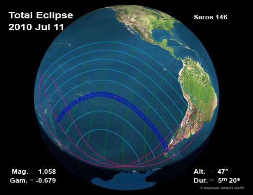
a total eclipse of the Sun is visible from within a narrow corridor that traverses Earth's southern Hemisphere. The path of the Moon's umbral shadow crosses the South Pacific Ocean where it makes no landfall except for Mangaia (Cook Islands) and Easter Island (Isla de Pascua). The path of totality ends just after reaching southern Chile and Argentina. The Moon's penumbral shadow produces a partial eclipse visible from a much larger region covering the South Pacific and southern South America
This web site has been established for the purpose of providing detailed predictions, maps, figures and information about this important event. The material here is adapted from Annular and Total Solar Eclipses of 2010 (NASA/TP-2008-214171). The publication date of this document is 2008 December. It is part of NASA's official eclipse bulletin publication series. Instructions and a form for ordering a hard copy of this publication can be found at: Order Form for NASA Eclipse Bulletins.
A special Web site is also available for the Annular Solar Eclipse of 2010 January 15.

0 Response to "2010 nasa special"
Post a Comment